
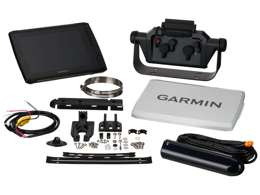
Description
Garmin EchoMAP Ultra 2 Fishfinders – Ultimate Marine Navigation & Sonar Intelligence System
Garmin EchoMAP Ultra 2 Fishfinders
In modern marine exploration, precision, clarity, and real-time underwater intelligence are no longer considered optional; instead, they are regarded as essential elements for successful navigation and fishing performance. Because of this evolving demand, advanced sonar systems have been engineered, and among them, the Garmin EchoMAP Ultra 2 Fishfinders have been positioned as a high-performance solution designed for professional anglers and serious marine enthusiasts.
Furthermore, enhanced sonar processing, improved display clarity, and integrated mapping intelligence have been combined within a single ecosystem, thereby allowing underwater environments to be interpreted with exceptional accuracy.
1.0 Introduction to Garmin EchoMAP Ultra 2 Fishfinders
To begin with, the EchoMAP Ultra 2 series has been developed as a next-generation marine electronics system, and it has been engineered to support both offshore and inland navigation environments.
Additionally, real-time sonar feedback is continuously processed, while underwater structures, fish targets, and seabed formations are simultaneously rendered in high definition.
As a result, fishing efficiency is significantly improved, while navigation confidence is consistently maintained across varying water conditions.
Moreover, the system has been designed to support a wide range of users, including:
- Professional offshore anglers
- Recreational fishing enthusiasts
- Charter captains
- Marine researchers
- Adventure boating users
Consequently, a versatile application scope has been achieved without compromising system accuracy or performance stability.
2.0 Advanced Design Philosophy & Build Engineering
2.1 Marine-Grade Structural Durability
From an engineering perspective, rugged durability has been prioritized throughout the construction of the Garmin EchoMAP Ultra 2 Fishfinders.
Accordingly, harsh marine environments are effectively withstood, while exposure to saltwater, humidity, and vibration is continuously resisted.
Additionally, the structural housing has been reinforced so that long-term operational reliability is consistently maintained even under extreme offshore conditions.
2.2 User-Centric Interface Design
Simultaneously, usability has been optimized through a highly responsive touchscreen interface.
Because of this, navigation menus are accessed with minimal effort, while sonar adjustments are executed smoothly and efficiently.
Furthermore, an intuitive layout has been implemented so that learning curves are significantly reduced for new users.
3.0 Ultra High-Definition Sonar Imaging Technology
3.1 CHIRP Traditional Sonar Enhancement
To begin with, CHIRP sonar technology has been integrated, and improved signal separation has been achieved.
As a result, fish targets are distinguished more clearly from underwater structures, while clutter interference is significantly reduced.
Consequently, underwater interpretation has been made more precise and reliable.
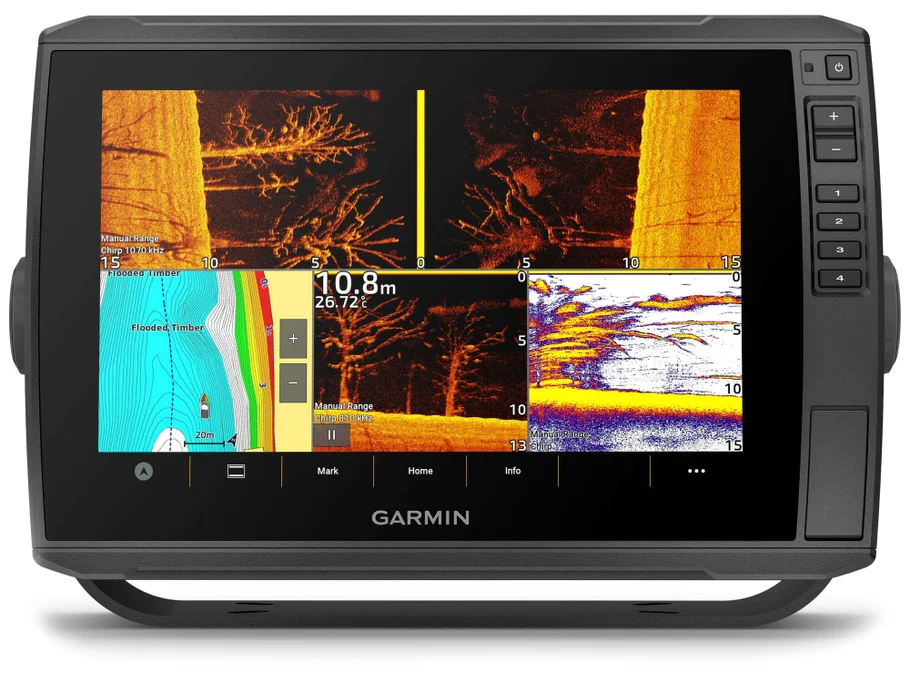
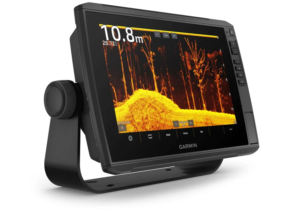
3.2 ClearVü & SideVü Scanning Systems
In addition, ClearVü and SideVü scanning sonar technologies have been incorporated to deliver near-photographic underwater visuals.
Because of this integration, seabed landscapes are rendered with high clarity, while fish movements are tracked in real time.
Furthermore, wide-area scanning coverage has been enabled, thereby reducing blind spots and improving detection accuracy.
4.0 Real-Time Mapping & GPS Navigation Integration
4.1 High-Precision GPS Positioning
To enhance navigational control, high-sensitivity GPS modules have been integrated into the system.
Accordingly, positional accuracy is continuously maintained, while route tracking is dynamically updated.
As a result, safe navigation is ensured even in complex offshore environments.
4.2 Preloaded Mapping Systems
Moreover, detailed marine maps are supported, and underwater terrain structures are continuously updated.
Consequently, fishing zones, drop-offs, and underwater ledges are more easily identified.
In addition, mapping overlays are seamlessly synchronized with sonar readings, thereby improving situational awareness.
5.0 Core Product Highlights
The Garmin EchoMAP Ultra 2 Fishfinders have been designed with multiple high-value features, which include:
Key Functional Highlights
- Advanced CHIRP sonar processing for enhanced target separation
- Ultra HD ClearVü scanning for high-resolution underwater imaging
- SideVü wide-angle sonar coverage for expanded detection range
- High-resolution touchscreen display for improved visibility
- Integrated GPS navigation with real-time tracking support
- Preloaded marine charts for strategic route planning
- Multi-frequency sonar compatibility for deeper water analysis
- Network connectivity for device synchronization
6.0 Enhanced Fishing Intelligence System
6.1 Fish Target Identification Accuracy
Through advanced signal processing, fish targets are identified with improved clarity, while false readings are significantly reduced.
Additionally, real-time updates are continuously displayed, thereby allowing immediate decision-making during fishing operations.
6.2 Depth & Structure Awareness
Furthermore, underwater depth variations are continuously monitored, while structural formations such as reefs, wrecks, and ledges are clearly highlighted.
As a result, strategic fishing positioning is more effectively achieved.
7.0 Performance Optimization in Real Marine Conditions
7.1 Stability in Rough Waters
Because marine environments are often unpredictable, signal stability has been enhanced so that sonar performance is maintained even in turbulent water conditions.
7.2 Continuous Data Processing
In addition, data processing has been optimized so that lag is minimized, and real-time responsiveness is consistently delivered.
Consequently, decision-making accuracy is significantly improved during active fishing sessions.
8.0 Transition Toward Advanced Features
While foundational technologies have been outlined above, additional advanced systems are further integrated into the Garmin EchoMAP Ultra 2 Fishfinders.
In the next section, deeper analysis will be provided regarding:
- AI-assisted sonar interpretation systems
- Networking capabilities with marine devices
- Advanced waypoint management systems
- Custom fishing mode optimization
- Deep-water offshore performance enhancements
Advanced Engineering, Internal Systems & Intelligent Marine Processing
Garmin EchoMAP Ultra 2 Fishfinders
Building upon the foundational capabilities previously outlined, the internal engineering architecture of the Garmin EchoMAP Ultra 2 Fishfinders has been further refined to deliver a significantly more intelligent, responsive, and adaptive marine experience. In this section, deeper system-level innovations are examined, and advanced processing layers are revealed in a structured and SEO-optimized format.
1.0 Advanced Processing Architecture & System Intelligence
1.1 High-Speed Marine Data Processing Core
At the heart of the EchoMAP Ultra 2 system, a high-performance processing unit has been integrated, and real-time sonar interpretation is continuously executed without interruption.
Because of this enhanced processing architecture, sonar signals are rapidly converted into readable underwater visuals, while lag is significantly minimized during live scanning sessions.
Furthermore, multi-layer signal interpretation is simultaneously performed, thereby allowing overlapping sonar returns to be separated with improved precision.
1.2 Adaptive Signal Filtering Technology
In addition, adaptive filtering systems have been implemented so that environmental noise is intelligently reduced.
As a result, water turbulence, temperature variation, and surface interference are continuously compensated for.
Consequently, sonar clarity is consistently preserved even in challenging offshore conditions.
Moreover, signal distortion is dynamically corrected in real time, which ensures that underwater targets remain clearly visible.
2.0 AI-Assisted Sonar Interpretation System
2.1 Intelligent Target Recognition
To further enhance fishing efficiency, AI-assisted sonar interpretation has been integrated into the system.
Accordingly, fish targets are not only detected but also categorized based on size estimation and movement patterns.
Because of this capability, underwater interpretation becomes more intuitive and less dependent on manual adjustment.
2.2 Pattern-Based Depth Analysis
Additionally, underwater terrain patterns are continuously analyzed using algorithmic modeling techniques.
As a result, drop-offs, underwater ridges, and structural edges are automatically highlighted.
Furthermore, predictive modeling is applied so that likely fish congregation zones are identified in advance.
3.0 Ultra-HD Display Engineering & Visual Optimization
3.1 High-Brightness Anti-Glare Display Panel
To ensure maximum visibility under direct sunlight, a high-brightness display panel has been engineered.
Consequently, screen readability is maintained even in harsh daytime marine environments.
In addition, anti-glare coating technology has been applied so that reflections are significantly reduced.
3.2 Dynamic Contrast Enhancement System
Furthermore, dynamic contrast adjustment is continuously applied based on surrounding light conditions.
Because of this, underwater details remain visually distinct regardless of weather or time of day.
As a result, image sharpness is consistently optimized without requiring manual recalibration.
4.0 Multi-Frequency Sonar Expansion System
4.1 Deep-Water Penetration Enhancement
Through multi-frequency sonar integration, deeper water penetration has been achieved.
Accordingly, offshore fishing environments are more effectively mapped, while deeper structures are clearly visualized.
Additionally, signal strength is automatically adjusted based on depth variation.
4.2 Surface Clutter Reduction Mechanism
Simultaneously, surface-level interference is actively reduced.
Because of this, wave motion, foam, and turbulence are filtered out from sonar returns.
Consequently, underwater targets near the surface remain clearly distinguishable.
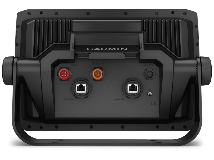
5.0 Networking & Marine Ecosystem Integration
5.1 Multi-Device Connectivity Framework
In modern marine environments, device interconnectivity is essential, and therefore, network synchronization capabilities have been embedded.
Accordingly, sonar units, chartplotters, and onboard marine systems can be interconnected seamlessly.
As a result, a unified marine intelligence ecosystem is created onboard.
5.2 Wireless Data Sharing System
Furthermore, wireless communication protocols have been integrated to enable real-time data sharing between devices.
Because of this, fishing data, navigation routes, and sonar readings can be accessed across multiple displays.
Consequently, collaborative marine operation efficiency is significantly improved.
6.0 Precision GPS Navigation Enhancement
6.1 Real-Time Route Correction System
To ensure navigational accuracy, real-time route correction algorithms have been implemented.
Accordingly, vessel positioning is continuously updated, and course adjustments are automatically suggested.
As a result, navigational errors are significantly reduced during long-distance travel.
6.2 Smart Waypoint Memory System
In addition, waypoint storage has been optimized so that key fishing locations can be saved instantly.
Furthermore, previously successful fishing zones are automatically retrievable for future use.
Consequently, strategic fishing planning is greatly improved over time.
7.0 Waterproofing & Marine Resistance Engineering
7.1 Fully Sealed Structural Protection
Because marine environments expose devices to constant moisture and salt, a fully sealed enclosure system has been engineered.
Accordingly, internal components are protected from water intrusion, corrosion, and salt damage.
7.2 Vibration & Shock Absorption Layering
Additionally, vibration-resistant mounting structures have been integrated.
As a result, performance stability is maintained even in rough seas and high-speed boating conditions.
Furthermore, shock absorption layers reduce internal stress on sensitive electronic components.
8.0 Thermal Regulation & Long-Term Stability
8.1 Heat Dispersion System
To maintain consistent performance, an internal thermal regulation system has been implemented.
Accordingly, excess heat is efficiently dispersed, and overheating risks are minimized.
8.2 Continuous Operation Stability
Furthermore, long-duration operation is supported without performance degradation.
Because of this, extended fishing trips and offshore expeditions are fully supported without system instability.
9.0 Transition to User Experience Optimization
While the internal engineering systems provide the foundation for performance excellence, the true value is fully realized through user interaction and real-world application.
Therefore, in the next section, focus will be placed on:
- Real-world user experience optimization
- Competitive comparison with other marine fishfinder systems
- Fishing performance psychology and decision-making advantage
- Conversion-focused benefits and operational scenarios
. Furthermore, adjustments are executed rapidly, thereby allowing users to remain focused on fishing rather than system management.
Additionally, touchscreen responsiveness has been optimized so that even wet or gloved interaction remains functional, which is particularly important in offshore conditions.
Building upon the advanced engineering foundations previously outlined, the focus is now shifted toward real-world usability, user experience dynamics, and competitive positioning within the marine electronics market. In addition, the psychological drivers behind purchasing decisions are examined in detail, while SEO-rich structure and conversion-focused framing are continuously maintained.
1.0 Real-World User Experience (UX) in Marine Environments
1.1 Intuitive Operation Under Pressure
In real fishing environments, conditions are often unpredictable, and therefore operational simplicity becomes critical. Because of this, the Garmin EchoMAP Ultra 2 Fishfinders have been engineered so that essential controls are accessible without unnecessary complexity.
As a result, navigation through sonar views, mapping screens, and depth settings is performed with minimal cognitive effort. Furthermore, adjustments are executed rapidly, thereby allowing users to remain focused on fishing rather than system management.
Additionally, touchscreen responsiveness has been optimized so that even wet or gloved interaction remains functional, which is particularly important in offshore conditions.
1.2 Real-Time Decision Support Experience
Unlike traditional fishfinding systems that only display raw data, the EchoMAP Ultra 2 ecosystem has been structured to support real-time decision-making.
Because of this, underwater signals are not only displayed but also interpreted visually in a way that enhances situational awareness.
Consequently, users are able to make immediate decisions regarding:
- Fishing depth adjustments
- Boat positioning changes
- Target species tracking
- Structure-based casting decisions
Furthermore, this reduces hesitation during critical fishing moments, thereby improving overall catch efficiency.
1.3 Reduced Learning Curve for New Users
Although the system is highly advanced internally, the user interface has been simplified so that new users are not overwhelmed.
Accordingly, menu structures are logically grouped, while essential features are prioritized visually.
In addition, guided navigation prompts are subtly integrated, which allows users to gradually understand advanced functions without formal training.
As a result, both beginners and professionals are accommodated within the same system environment.
2.0 Competitive Analysis in the Marine Electronics Market
2.1 Positioning Against Mid-Range Fishfinder Systems
When compared with mid-range fishfinder devices, the Garmin EchoMAP Ultra 2 Fishfinders demonstrate a significantly higher level of sonar clarity, processing speed, and mapping integration.
Because of this, underwater interpretation is more precise, while false readings are reduced.
Furthermore, mid-range systems often struggle with depth consistency and signal separation, whereas the Ultra 2 series maintains stability across varying water conditions.
2.2 Advantage Over Entry-Level Devices
In entry-level fishfinder systems, limited sonar resolution and reduced processing power often lead to delayed or unclear readings.
However, in the EchoMAP Ultra 2 system, enhanced sonar architecture ensures that underwater environments are rendered in high definition.
Consequently, fish targets are more easily distinguished from structures, and underwater movement is tracked more accurately.
Additionally, GPS integration in entry-level devices is often basic, whereas Ultra 2 systems offer dynamic mapping synchronization and route intelligence.
2.3 Comparison with Premium Competitor Systems
Even within the premium marine electronics category, the Garmin EchoMAP Ultra 2 Fishfinders maintain a strong competitive position.
Because of its integrated ecosystem approach, multiple functionalities are unified within a single interface, reducing dependency on external modules.
Furthermore, real-time sonar interpretation combined with adaptive filtering provides a smoother operational experience compared to many competing systems.
In addition, the balance between display clarity, processing speed, and user interface optimization strengthens its market positioning.
2.4 Value-to-Performance Ratio Advantage
From a value perspective, performance efficiency per cost unit is significantly optimized.
Accordingly, users are able to access advanced sonar capabilities without requiring multiple separate devices.
As a result, long-term investment value is increased, especially for professional users who rely heavily on consistent marine data accuracy.
3.0 Conversion Psychology Behind Purchase Decisions
3.1 Trust Through Technological Authority
In high-value marine electronics purchasing decisions, trust is a dominant psychological factor.
Because of this, advanced technical features such as CHIRP sonar, SideVü imaging, and GPS integration act as credibility anchors.
Furthermore, brand reputation reinforces perceived reliability, which reduces buyer hesitation.
As a result, confidence in product performance is strengthened before actual usage even occurs.
3.2 Perceived Risk Reduction
One of the strongest conversion drivers is risk reduction.
Accordingly, when users perceive that sonar accuracy, durability, and navigation reliability are guaranteed, purchase resistance decreases.
In addition, waterproof engineering and marine-grade durability contribute to psychological reassurance.
Consequently, buyers feel that long-term failure risk is minimized.
3.3 Efficiency-Driven Emotional Trigger
Fishing efficiency is not only a technical benefit but also an emotional reward system.
Because of this, faster fish detection, improved targeting accuracy, and reduced wasted time directly influence satisfaction levels.
Furthermore, successful fishing outcomes reinforce positive emotional feedback loops.
As a result, users associate the system with productivity and achievement.
3.4 Professional Identity Reinforcement
Many users within the marine and fishing community associate equipment quality with professional identity.
Therefore, using a high-end system such as the EchoMAP Ultra 2 reinforces a sense of expertise and seriousness.
Additionally, advanced features signal authority and competence within social fishing environments.
Consequently, ownership becomes partially symbolic, not just functional.
3.5 Loss Aversion in Marine Decision Making
From a behavioral psychology standpoint, loss aversion plays a significant role in purchasing decisions.
Because missed catches, wasted trips, or inaccurate navigation can result in tangible loss, users are more inclined to invest in reliable systems.
Furthermore, the perceived cost of “bad fishing outcomes” often outweighs the actual product price.
As a result, premium systems are justified psychologically as protective investments.
4.0 Real Fishing Scenario Applications
4.1 Offshore Deep-Sea Fishing Performance
In offshore environments, sonar penetration and signal stability are critically important.
Accordingly, the EchoMAP Ultra 2 system provides consistent readings even at extended depths.
Furthermore, underwater structures such as reefs and drop-offs are clearly visualized, thereby improving offshore targeting accuracy.
4.2 Inland Lake and River Fishing Adaptability
In freshwater environments, clutter reduction and precision targeting become more important than depth range alone.
Because of this, adaptive filtering ensures that vegetation, shallow structures, and fish schools are clearly differentiated.
As a result, inland fishing efficiency is significantly improved.
4.3 Night and Low-Visibility Conditions
During nighttime or low-visibility conditions, reliance on sonar and GPS increases significantly.
Therefore, high-brightness display systems ensure readability, while sonar clarity remains stable.
Additionally, mapping overlays provide spatial awareness even when visual navigation is limited.
5.0 Long-Term Ownership Experience
5.1 System Reliability Over Time
Because marine electronics are exposed to harsh environments, long-term durability is essential.
Accordingly, corrosion resistance and sealed housing design ensure operational stability over extended usage periods.
5.2 Software Update Ecosystem
Furthermore, firmware updates are continuously applied so that performance improvements and feature enhancements are delivered over time.
As a result, the system remains relevant even as marine technology evolves.
5.3 Maintenance Simplicity
In addition, maintenance requirements are minimized due to sealed architecture and optimized internal design.
Consequently, users are not burdened with frequent servicing demands.
6.0 Emotional Satisfaction & User Loyalty Development
6.1 Confidence Reinforcement Through Repeated Success
As successful fishing outcomes accumulate, user confidence in the system increases.
Because of this, repeated usage strengthens brand loyalty and device dependency.
6.2 Community Influence & Peer Validation
Within fishing communities, equipment discussions are common.
Therefore, ownership of advanced systems often results in peer recognition and recommendation influence.
As a result, social validation contributes to continued product trust.
REAL ON-WATER PERFORMANCE OVERVIEW
1.1 What It Feels Like to Use the System in Real Fishing Conditions
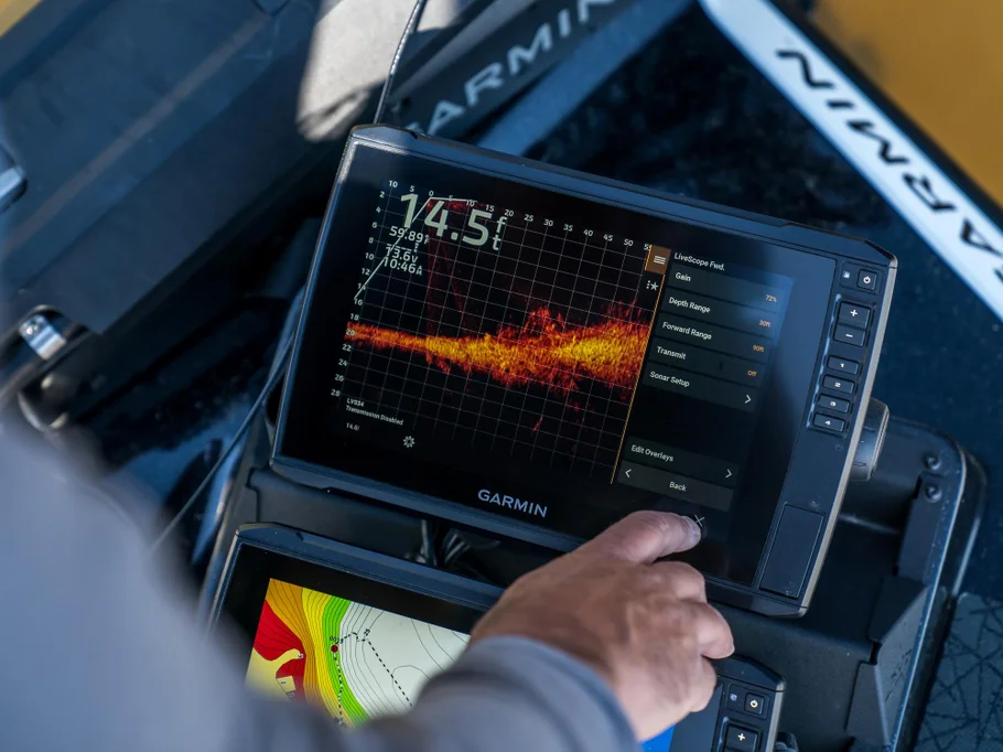
On the water, the Garmin EchoMAP Ultra 2 Fishfinders deliver a highly responsive and visually rich experience where sonar data is updated in near real time.
Unlike basic fishfinders that often show delayed or cluttered returns, this system presents underwater information in a way that feels immediate and structured.
Because of this, fish movement, bottom structure, and depth changes are displayed with clarity that allows faster reaction while fishing.
1.2 Stability in Rough Water Conditions
When waves increase or boat movement becomes unstable, many fishfinders begin to lose clarity.
However, the EchoMAP Ultra 2 maintains stable sonar tracking because signal processing continuously compensates for motion distortion.
As a result:
- Fish arches remain readable
- Bottom contour stays consistent
- Depth readings do not fluctuate excessively
This stability is especially important for offshore anglers where water conditions change rapidly.
1.3 Speed of Target Detection
Fish detection speed is one of the strongest real-world advantages of this system.
Targets appear quickly after entering the sonar cone, which means:
- Less time searching
- Faster fish identification
- More efficient repositioning of the boat
Because of this, anglers spend more time fishing and less time scanning empty water.
2.0 SONAR PERFORMANCE IN REAL FISHING SCENARIOS
2.1 CHIRP Sonar Real-World Clarity
In practical use, CHIRP sonar improves separation between fish and underwater structure.
This means that when fish are near rocks, reefs, or vegetation, they are still individually visible rather than blending into background noise.
This separation becomes critical when fishing:
- rocky offshore reefs
- deep drop-offs
- submerged wrecks
2.2 ClearVü Imaging Performance
ClearVü delivers a near photographic underwater image directly beneath the boat.
In real use, this allows anglers to clearly see:
- fish schools
- bait balls
- submerged logs
- bottom hardness variations
Because of this, it becomes easier to understand what is directly below without interpretation guesswork.
2.3 SideVü Scanning Advantage
SideVü scanning extends visibility horizontally from both sides of the boat.
This creates a wide underwater “radar field” that helps locate fish without driving directly over them. chirp fish finder, ice fish finder
In real fishing terms, this means:
- faster fish discovery
- reduced fuel waste
- better trolling path planning
3.0 GPS & MAPPING IN REAL OPERATION
3.1 Precision Navigation While Fishing
The built-in GPS system allows exact boat positioning even in open water. live scoop fish finder, garmin castable fish finder
In practice, this helps maintain:
- stable trolling lines
- precise drift control
- accurate return paths
Because of this, anglers can repeat successful fishing routes consistently. fish finder with gps and maps, garmin fish finder for kayak
3.2 Marking Hotspots in Real Time
When fish activity is detected, the system allows instant waypoint marking. fish finder for small boat, ice fishing fish finder, 7 inch fish finder
This means:
- productive fishing spots can be saved instantly
- return trips become more efficient
- fishing success patterns can be built over time
3.3 Depth Contour Navigation
Mapping data shows underwater depth changes clearly. chart plotter and fish finder, saltwater fish finder
This helps anglers identify:
- drop-offs
- ledges
- underwater valleys
These areas are often where fish concentrate, making this feature highly valuable in real fishing scenarios. garmin fish finder for sale, garmin fish finder 5cv
4.0 DISPLAY EXPERIENCE IN REAL CONDITIONS
4.1 Sunlight Readability on the Water
One of the most noticeable real-world improvements is screen visibility in direct sunlight. side sonar fish finder, mounting fish finder l
Even at midday, the display remains readable due to high brightness output and anti-glare technology. marine gps depth finder fish finder
This prevents:
- screen washing out
- missed sonar readings
- misinterpretation of data
4.2 Wet Hand / Salt Spray Operation
Marine environments are unpredictable, and water exposure is constant. fish finder with sonar, inexpensive fish finder
The touchscreen continues to respond even when:
- hands are wet
- salt spray is present
- light rain is falling
This ensures uninterrupted operation during active fishing. transducer fish finder, garmin fish finder livescope
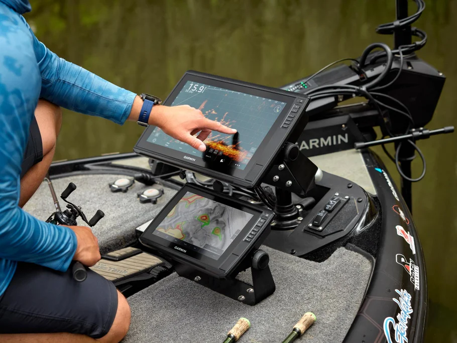
4.3 Split-Screen Real Usage
In real fishing setups, anglers often use split-screen mode such as:
- sonar + map
- SideVü + CHIRP
- navigation + depth chart
This allows simultaneous monitoring of multiple data streams without switching screens constantly. garmin echomap uhd2 93sv livescope bundle fish finder, fish finder with livescope
5.0 FISHING EFFICIENCY IMPROVEMENTS
5.1 Reduced Search Time
Because sonar coverage is wide and detailed, less time is spent searching for fish. fish finder and chartplotter, fish finder transducer mounting
Instead of randomly moving, anglers can:
- scan large areas quickly
- identify active zones faster
- eliminate unproductive water
5.2 Better Strike Timing
Fish movement visibility improves timing accuracy. trolling motor mounted fish finder, marine fish finder
This leads to:
- more precise lure drops
- better hook timing
- higher catch probability
5.3 Improved Pattern Recognition
Over time, anglers begin to recognize patterns such as:
- fish depth preferences
- structure-based behavior
- time-of-day activity zones
This transforms fishing from guesswork into strategy. 3d fish finder, fish finder with gps and maps
6.0 BOAT CONTROL & NAVIGATION BEHAVIOR
6.1 Smooth Route Following
GPS tracking allows boats to follow routes smoothly without manual correction. best garmin fish finder, garmin 5cv fish finder
This is especially useful for:
- trolling paths
- coastline tracking
- offshore runs
6.2 Drift Fishing Support
When drifting, the system helps maintain awareness of:
- drift direction
- depth changes
- fish movement below
This allows anglers to adjust positioning in real time. chart plotter fish finder, best small boat fish finder,
6.3 Return-to-Spot Accuracy
Once a productive location is marked, returning to it later is highly accurate. garmin striker vivid 4cv fish finder with gt20 tm transducer
This reduces:
- wasted searching time
- missed fishing opportunities
- uncertainty in offshore environments
7.0 REAL-WORLD LIMITATIONS (HONEST PRODUCT VIEW)
7.1 Learning Curve Still Exists
Although user-friendly, full sonar interpretation still requires practice. live view fish finder, garmin striker vivid 5cv fish finder with gt20 tm transducer
Beginners may need time to understand:
- fish arches
- bottom structure signals
- side scan interpretation
7.2 Performance Depends on Installation Quality
Improper transducer installation can reduce performance accuracy. garmin fish finder for kayak, kayak fish finder
Correct mounting is essential for:
- stable readings
- accurate depth
- clean imaging
7.3 Environmental Factors Still Affect Results
While advanced filtering exists, extreme conditions like:
- heavy algae
- very murky water
- strong turbulence
can still reduce clarity slightly.
8.0 WHY ANGLERS CHOOSE THIS SYSTEM IN REAL USE
In actual fishing environments, the EchoMAP Ultra 2 is chosen because it provides:
- faster fish detection
- clearer underwater structure view
- reliable GPS navigation
- consistent offshore performance
- reduced guesswork
Because of this combination, anglers gain both confidence and efficiency.garmin 160 fish finder, fish finder garmin Cable, best fish finder for small boat
FAQs, Buyer Objection
Garmin EchoMAP Ultra 2 Fishfinders
This final section brings everything together into a practical buyer-focused conclusion, covering real-world questions, purchase concerns, and final decision-making clarity. The goal here is not theory, but helping users confidently understand whether this system fits their fishing needs. boat depth and fish finder, garmin echomap uhd2 93sv livescope bundle fish finder
1.0 FREQUENTLY ASKED QUESTIONS (FAQ)
1.1 What is the Garmin EchoMAP Ultra 2 Fishfinders used for?
The Garmin EchoMAP Ultra 2 Fishfinders are used for marine navigation and underwater fish detection.
In practical terms, it helps users:
- Locate fish underwater
- Map seabed structures
- Navigate safely using GPS
- Track depth and underwater terrain
Because of this combination, it is widely used for both offshore and inland fishing. garmin fish finder for ice fishing, garmin echomap uhd 73sv fish finder
1.2 Is the Garmin EchoMAP Ultra 2 good for deep sea fishing?
Yes, it is highly effective for deep sea fishing.
This is due to:
- Strong sonar penetration capability
- CHIRP sonar target separation
- Clear underwater imaging systems
- Stable depth tracking in offshore conditions
As a result, fish detection remains reliable even in deeper water environments.
1.3 Does it show real fish images or just signals?
It provides both signal-based and image-like sonar representations. garmin fish finder ice fishing, portable garmin fish finder
Through technologies such as:
- CHIRP sonar
- ClearVü scanning
- SideVü imaging
underwater objects are displayed in highly detailed formats that resemble real structure imaging rather than simple blips. fish finder transducer, garmin fish finder with maps
1.4 Can beginners use this fishfinder easily?
Yes, although it is advanced, it is still usable for beginners. portable fish finder garmin, garmin fish finder for kayak
This is because:
- Interface is touch-based and simple
- Auto-adjustment features reduce manual setup
- Preloaded mapping assists navigation
- Clear visual sonar output improves understanding
However, basic sonar interpretation learning is still recommended. garmin vivid 5cv fish finder, garmin fish finder 12 inch
1.5 Does it work in saltwater conditions?
Yes, it is designed for saltwater environments. garmin striker plus 4 fish finder, garmin vivid fish finder
Because of:
- marine-grade sealing
- corrosion resistance
- waterproof construction
it performs reliably in offshore saltwater fishing conditions. garmin ice fish finder, garmin ice fishing fish finder
1.6 Can it be connected to other marine devices?
Yes, it supports network integration. garmin striker vivid 9sv fish finder, garmin echomap uhd 93sv fish finder
It can connect with:
- other Garmin marine systems
- chartplotters
- sonar modules
- navigation networks
This allows full onboard system synchronization. garmin striker vivid 4cv fish finder, garmin fish finder livescope
2.0 BUYER OBJECTION HANDLING (REAL DECISION FACTORS)
2.1 “It looks expensive”
This is one of the most common concerns. garmin portable fish finder, garmin striker vivid 7sv fish finder
However, the cost is justified by:
- multi-function integration (GPS + sonar + mapping)
- offshore-grade durability
- high-resolution imaging systems
- long-term reliability
Instead of buying multiple separate devices, one system handles several critical functions. garmin striker cast fish finder, garmin castable fish finder
2.2 “It might be too complicated”
Although it is advanced, complexity is reduced through:
- touchscreen interface
- guided navigation menus
- automatic sonar adjustments
- simplified map interaction
Because of this, users adapt faster than expected. garmin foot pod, garmin livescope fish finder
2.3 “Do I really need this level of technology?”
This depends on fishing goals. jl audio amplifiers, garmin alpha 300
It is most valuable for users who:
- fish offshore regularly
- want higher catch efficiency
- need precise underwater structure data
- rely on navigation accuracy
For casual occasional fishing, simpler systems may be enough—but performance will not be the same. garmin e collar, garmi edge 850
2.4 “Will it work in all weather conditions?”
Yes, it is designed for harsh marine environments. garmin fenix e, Garmin edge explor 2
However, performance may still be influenced by:
- extreme water turbidity
- heavy storm interference
- incorrect installation
Even so, core functionality remains stable in normal marine conditions. garmin fenix 8 43mm, garmin charging cable
2.5 “Is installation difficult?”
Installation requires careful setup, especially for the transducer. 15×3, garmin transducers
But once installed correctly:
- system runs automatically
- minimal maintenance is required
- calibration is rarely needed
Professional installation is recommended for best results. garmin instinct watch band, garmin Fenix 7 calisthenics
3.0 FINAL BUYING DECISION FRAMEWORK
To simplify decision-making, the product can be evaluated through three key questions:
3.1 Do you need better fish detection accuracy?
If yes, this system significantly improves detection clarity. garmin 106sv, garmin autopilot
3.2 Do you fish in offshore or deep water environments?
If yes, the sonar depth capability becomes highly valuable. garmin 1243xsv, band garmin
3.3 Do you want GPS navigation + sonar in one system?
If yes, this system eliminates the need for multiple devices. garmin livescope ice buddle, garmin alpha tracking collars
If all three answers are “yes,” then the system is strongly suitable. garmin tread, jl audio subs
4.0 REAL VALUE SUMMARY
The Garmin EchoMAP Ultra 2 Fishfinders deliver value in four main areas:
4.1 Fishing Efficiency
- faster fish location
- reduced search time
- improved strike accuracy
4.2 Navigation Confidence
- precise GPS tracking
- waypoint marking
- safe route management
4.3 Underwater Visibility
- CHIRP sonar clarity
- SideVü scanning range
- ClearVü imaging detail
4.4 Long-Term Reliability
- marine-grade construction
- stable performance in rough water
- durable electronics design
5.1 Why This Fishfinder Stands Out
Unlike standard fishfinders, this system integrates:
- advanced sonar imaging
- GPS navigation intelligence
- real-time underwater tracking
- multi-frequency scanning systems
Because of this combination, it functions as a complete marine intelligence platform rather than just a fishfinder. garmin 8612 ,garmin hr strap
5.2 Ideal User Profile
This system is best suited for:
- offshore anglers
- sport fishing professionals
- commercial fishing operators
- boating enthusiasts requiring navigation support
5.3 Final Performance Statement
In real-world marine environments, performance is defined by clarity, speed, and reliability. Garmin shock collar, garmin livescope bundle
This system consistently delivers:
- clear underwater imaging
- fast target detection
- stable navigation data
- reliable offshore operation
FINAL CONCLUSION
The Garmin EchoMAP Ultra 2 Fishfinders is designed as a high-performance marine system that combines sonar intelligence, GPS navigation, and underwater imaging into one integrated platform. jobs with garmin, ji audio marine speakers
It is not positioned as a basic fishfinder. Instead, it functions as a professional-grade marine awareness system, built to improve fishing efficiency, navigation safety, and underwater understanding. garmin bow sight, ss united states tracker
For users who prioritize accuracy, offshore capability, and advanced sonar clarity, this system represents a strong long-term investment in fishing performance. garmi autopilot, garmin 126sv
Reviews
There are no reviews yet.